Mobile scanning system AGM-MS5
The mobile scanning system AGM-MS5 is a compact, light and cost-effective solution for mobile scanning.
Usual applications:
› engineering surveys;
› creating three-dimensional models of infrastructure objects;
› inventory of the roads and railways;
› GIS for various purposes;
› facades photography;
› and others.
Scanning system inside of AGM-MS5.100 (up to 2 scan heads) with range of up to 200 m, light and compact.
Spherical panoramic camera FLIR (earlier PointGrey) LadyBug 5+ enables the capture of spherical panoramic pictures at a resolution of up to 30 MP with a frame rate of up to 30 fps, allowing you to cover 90% of the sphere.
The high accuracy inertial movement units (IMU) inside the AGM-PS model, manufactured in different countries (including the Russian Federation) and designed and developed around the fiber optic gyros technology (FOG), are not subject to any export restrictions or sanctions.
Light, compact and cost-effective.
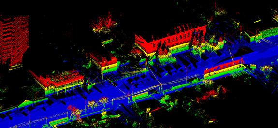
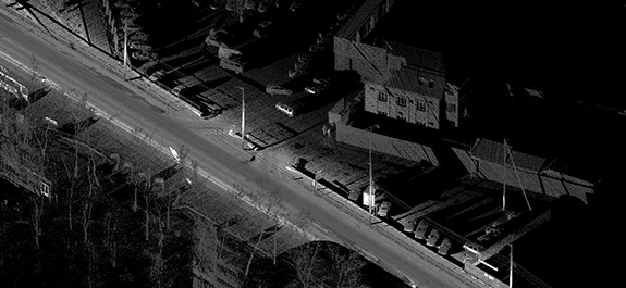
The technology of mobile laser scanning is based on the integration of distance measurements to terrain objects using a high speed laser range finder and navigation measurements necessary to determine coordinates of mobile laser scanner's movement and angles of its orientation.
Mobile laser scanning is accompanied by GNSS measurements on a network of base stations. On the basis of these measurements, differential corrections are made to the solution of trajectory obtained from the navigation system of mobile scanner.
As a result of joint processing of range finders measurements and trajectory, an array of laser reflection points is obtained, in which each point has spatial coordinates XYZ in the required coordinate system with high accuracy. The density of mobile laser scanning points can reach tens of thousands per square meter of survey. Simultaneously with the laser scanning, panoramic photographing is also carried out. Panoramic survey is carried out together with the definition of external orientation parameters of the images using the navigation systems AGM-PS. This allows you to "snap" panoramic images to the site of the terrain with high accuracy.