Equipment
We offer high-precision equipment of our own production for various applications.
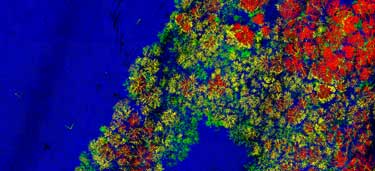
Airborne laser scanning and digital aerial photography - without alternative technologies for large forest areas
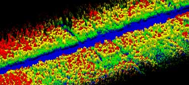
Airborne and terrestrial laser scanning provides fast, accurate, presicion and detailed digital terrain models, including hard-to-reach ones, for subsequent mapping of vegetation cover and for conducting a set of accompanying measurements (tree heights, diameter of trunks at any height, crown area, biomass, etc.) by non-contact automated methods.
Integration of these technologies into forestry will ensure reliable, accurate and highly effective monitoring of forestry and use of forest resources.
All works are carried out in a single coordinate system, the data obtained can form the basis for various sectoral geographic information systems (GIS). Significant reduction in the volume of field work, the transfer of analytical processes to desktop conditions in conjunction with high productivity of modern remote sensing techniques make using of laser scanning technologies the most cost-effective solution when working with large forest areas.
We offer high-precision equipment of our own production for various applications.
Our software allows to effectively process large volumes of remote sensing data.
We offer to our customers the complete production workflow.