Airborne laser scanner AGM-AS35
AGM-AS35 is aimed for airborne laser scanning using light planes, helicopters and fixed wings UAVs and VTOLs with long flight times.
The equipment is designed for simultaneous 3D airborne laser scanning and digital aerial photography. The compact and lightweight body with an integrated inertial navigation system makes it easy to integrate the lidar into the cargo compartment of an unmanned aircraft or the external gimbal of a light aircraft or helicopter.
A choice of various inertial systems, MEMS and FOG, is possible. It guarantees the required accuracy of laser point clouds and exterior orientations of aerial photographs.
The compact design and fully autonomous operation make this solution ideal for drones with long flight times.
Airborne laser scanning technology is based on the integration of high-speed laser rangefinder and inertial navigation system data, which determines the position of the aircraft in the required coordinate system during the surveing process with high accuracy and precision.
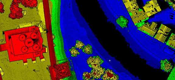
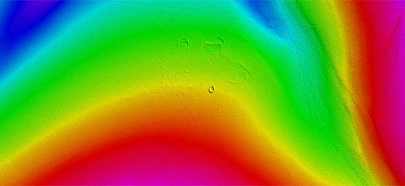
The result of the scanning is a 3D cloud of laser reflection points, from which it is possible to build high-precision digital elevation models (DEM) and highly detailed digital terrain models (DTM).
Simultaneously with airborne laser scanning, aerial photography is carried out. We use a high-resolution digital camera and determine the exterior orientations of images by the data of the inertial navigation system AGM-PS. It allows to build an orthophoto without the laborious process of phototriangulation.
Unlike the airborne laser scanner for UAV AGM-MS3, the AGM-AS55 laser scanner is designed for installation on manned carriers and can survey several hundred linear or square kilometers during one flight.
The equipment is used in engineering surveys for creating large-scale cartographic products, monitoring power transmission lines, and for other purposes requiring high-precision geodetic measurements.